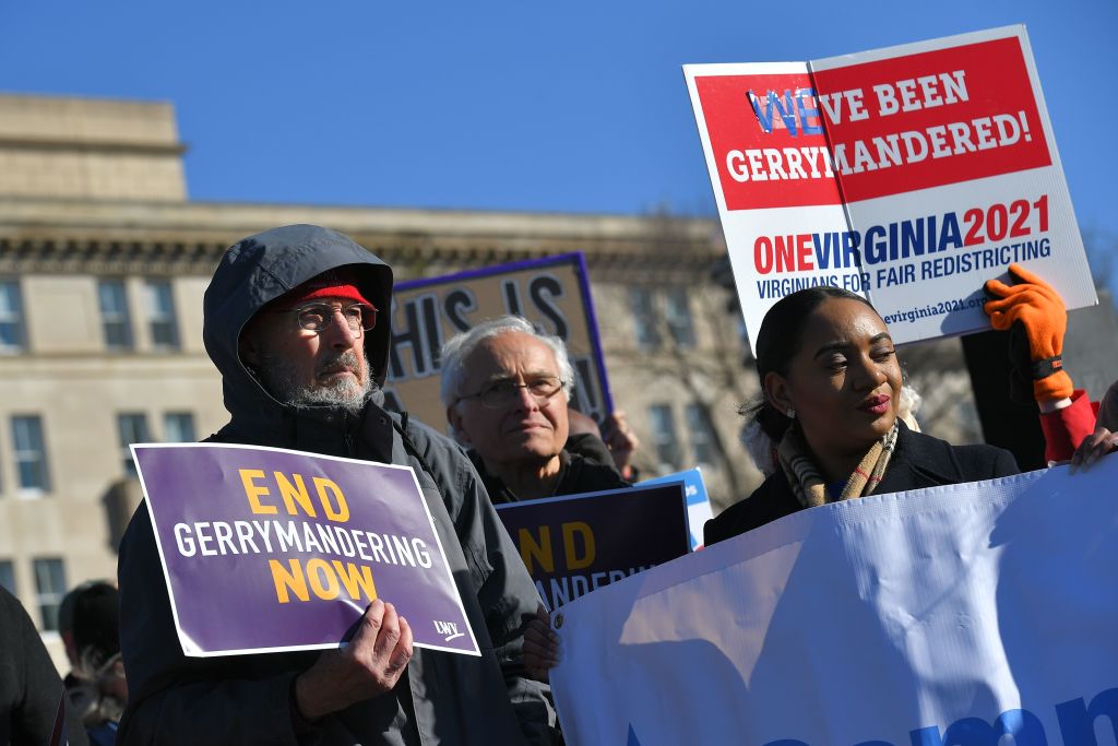
On Feb. 19, Wisconsin governor Tony Evers signed new state legislative maps into law, ending a decade-long political and judicial dogfight that culminated in the state supreme court ruling that Wisconsin’s maps violated the state constitution. Those maps were egregious examples of gerrymandering — the practice of manipulating the borders of congressional and state districts to benefit one party at the expense of the other.
The practice is as old as the republic. Politicians in states such as Virginia, North Carolina, and South Carolina adopted it as early as the late 18th century. And since then, gerrymandering has grown into one of the greatest threats to American democracy. It has helped render over 90% of congressional and state districts uncompetitive, leaving tens of millions of voters rightfully feeling like their vote does not matter in elections that have been preordained by the district shapes. Thankfully, the last few decades have produced a potential solution: independent redistricting commissions, which are, increasingly, the key to restoring American democracy.
Gerrymandering was first put on the map in a big way by Elbridge Gerry, a founding father who later served as the fifth vice president.
Gerry had fought against direct election of representatives to the House at the Constitutional Convention. He was concerned about “the evils” that stemmed from an “excess of democracy.” This worry shaped what would become his most lasting contribution to American politics.
Read More: To End Gerrymandering, Change How We Elect Congress
In 1812, the Massachusetts legislature, controlled by the Democratic-Republican Party, sought to disempower the Federalist opposition in the state senate by redrawing their districts. The new map contained oddly shaped districts the Federalists charged were “carvings and manglings.” Gerry, the governor, signed the new redistricting into law, prompting the disgruntled Federalists to coin the derogatory portmanteau “gerrymander,” blending “Gerry” and “salamander.”
The Federalists were right to be aggrieved: the new map worked exactly as intended. Both parties received roughly 50,000 votes for state senate in the 1812 elections. Yet, thanks to their gerrymandered map, Democratic-Republicans captured 29 seats to the Federalists’ 11.
Gerrymanders continued to be brutally effective throughout the first half of the 19th century. An 1852 redistricting of Indiana, for example, gave Democrats 10 of 11 congressional districts even though they won only 53% of the popular vote.
Yet, the practice of district butchering truly took off after the states ratified the 15th Amendment granting Black men the right to vote in 1870. Southern states intensified their gerrymandering to dampen or dilute the Black voice. In 1882, for example, white Democrats, who had regained control of the South Carolina legislature, created a meandering “boa constrictor” district that consolidated Black voters. This map enabled all of the other districts to comfortably elect white representatives, despite a majority of the state population being Black.
Gerrymandering was one of many tools — including poll taxes, literacy tests, and intimidation — that Southern whites used to disenfranchise Black voters.
This continued into the early 20th century, but white Southerners also added a new twist: the refusal to redraw districts. They hoped that doing so would over-represent conservative white rural voters, while stuffing urban areas — increasingly predominately non-white — into the smallest number of districts possible. Alabama, for example, redrew its districts in 1901 and then left them unchanged for 60 years. By the 1960s, one of Alabama’s rural state legislative districts contained about 15,000 people while the district containing Birmingham, with a large Black population, had more than 600,000.
In the 1960s, several Supreme Court decisions, most especially those in Baker v. Carr and Wesbury v. Sanders, sought to curb racial gerrymandering. The latter mandated that, in each state, congressional districts had to be of equal size. But the justices declined to outright ban gerrymandering.
Over the ensuing decades, the rise of computer technology made the practice an even more potent weapon. By the early 2000s, professional redistricting software, such as Maptitude, enabled legislators and strategists to combine demographic and past voting data with ever increasing speed of computation to optimize the process and draw more devastating gerrymanders than Gerry could ever have imagined. The effectiveness of this software has only grown over time. Twenty years ago, a computer could generate a few hundred possible maps in seconds. Now that number is in the tens of thousands and growing exponentially.
Layering various datasets and moving census blocks around allow maps to be tweaked with surgical precision, the digital scalpel ruthlessly carving up counties, towns, and neighborhoods. The software is publicly available and anyone with some understanding of local politics and a little dexterity with coding can play the gerrymandering game, securing their own party’s election success.
As Justice Elena Kagan wrote in her 2019 dissenting opinion in Rucho v. Common Cause, in which the majority determined that the federal courts cannot adjudicate partisan gerrymandering, “Election Day . . . is the foundation of democratic governance. And partisan gerrymandering can make it meaningless.”
In response to the increasing efficiency of gerrymandering, activists have developed a weapon to fight back: taking map drawing away from partisan legislatures and giving it to independent citizen commissions.
These commissions have no politicians and the members are screened for biases, or balanced by party. They are tasked with drawing district lines in a nonpartisan way that respects the guidelines and rules of geography, fairness, and opportunity. Many countries, including the U.K., Australia, and Canada, employ such commissions.
They have proved more successful than panels appointed by politicians, even if they are bipartisan. In 2021, for example, Virginia’s politically appointed advisory commission could not agree on a map and the state supreme court had to step in. Bickering and political favoritism also complicated the work of bipartisan commissions in Montana, New Jersey, and New York.
Commissions also only solve the problem of gerrymandering if they have the final say in drawing districts. In Ohio, Utah, and New Mexico, the dominant party — in the first two cases Republicans, and in the latter, Democrats — simply ignored their commission’s work and drew a gerrymander.
Commissions aren’t a cure-all because voters have increasingly self sorted by geography, with Democrats clustering around cities and Republicans more spread out in rural areas.
Nevertheless, there is strong evidence that independent commissions do reduce gerrymandering overall. The liberal Center for American Progress concluded in 2016 that maps drawn by independent commissions have almost twice as many competitive districts as their legislature-drawn counterparts. This was substantiated, for example, in California, where the average percentage of competitive districts went from 5.6% in the decade preceding the 2010 introduction of an independent commission to 14.6% since then.
That has led to a push in states with referendum processes to take the power to district away from legislatures. In 2016, a fed-up young Michigan activist, Katie Fahey, posted on Facebook: “I’d like to take on gerrymandering in Michigan. If you’re interested in doing this as well, please let me know.”

Her organization Voters Not Politicians soon had thousands of volunteers across the state who gathered 400,000 signatures to put Proposal 2 on the 2018 ballot. Despite lawsuits and attempts by conservative groups to quash the initiative, it passed by more than a 20-point margin. Michigan now has a districting commission whose 13 members are prohibited from having ties to politics. The map they produced is one of the most balanced and competitive in the nation.
This suggests that, at least in states with a referendum process, voters have a pathway to more competitive general elections and more choice among candidates. It’s not perfect — states without such processes like Texas and North Carolina continue to have outrageously gerrymandered maps that give the majority party a dramatically disproportionate share of the seats. This will continue to be the case for as long as the fundamental democratic process of districting is in the hands of politicians and not under the purview of the voters. But it points to the importance of addressing gerrymandering and entrusting independent commissions with mapmaking across the country. Only that can ensure that every vote counts and representatives have to be responsive to their constituents.
Ismar Volić is a professor of mathematics at Wellesley College and the director of the Institute for Mathematics and Democracy. His book Making Democracy Count: How Mathematics Improves Voting, Electoral Maps, and Representation will be published in April.
Made by History takes readers beyond the headlines with articles written and edited by professional historians. Learn more about Made by History at TIME here. Opinions expressed do not necessarily reflect the views of TIME editors.
More Must-Reads from TIME
- Cybersecurity Experts Are Sounding the Alarm on DOGE
- Meet the 2025 Women of the Year
- The Harsh Truth About Disability Inclusion
- Why Do More Young Adults Have Cancer?
- Colman Domingo Leads With Radical Love
- How to Get Better at Doing Things Alone
- Michelle Zauner Stares Down the Darkness
Write to Ismar Volić / Made by History at madebyhistory@time.com
