Predicting lifespan isn’t an exact science. U.S. life expectancy is currently estimated at 78.6 years, but that one number doesn’t tell the whole story. Genes, gender, lifestyle and luck all play an important part, but it’s impossible to know exactly how much and in what proportion each ingredient influences a person’s longevity.
More from TIME
The single best predictor, though, might not be one of these factors at all. A growing body of evidence suggests it may be a person’s zip code that holds the most information about how long they’ll live. Researchers from the New York University School of Medicine recently used data from NYU Langone Health’s City Health Dashboard to find that 56 of the U.S.’ 500 largest cities are home to people who can expect to live at least 20 fewer years than those in other neighborhoods, even if they’re just blocks or miles away.
In Chicago, the city with the largest disparity, life expectancy varied by up to 30.1 years, and in both Washington, D.C. and New York City it varied by more than 27 years. Meanwhile, residents of Fishers, Ind., the city with the smallest gap, can expect to die within about 2.5 years of their neighbors across the city.
A zip code’s influence on the health of those living there is multifold. Where you live directly affects your health in a number of ways, from exposure to air pollution and toxins to accessibility of healthy food, green space and medical care. But it’s also a more subtle indicator of socioeconomic factors that are inherent to health and longevity, including race and income. The cities with the widest gaps in life expectancy, the NYU researchers found, were those that were most segregated by race and ethnicity, with predominantly minority neighborhoods often facing obstacles—like poverty, untenable housing costs, unemployment and subpar social services—that didn’t affect majority white neighborhoods to the same degree.
Links between race, poverty and health have been reinforced by years of inequality, and disentangling them won’t be easy. But understanding the ties between zip code and health can help local lawmakers, public-health officials and community representatives begin to level the playing field for their residents, the NYU researchers argue.
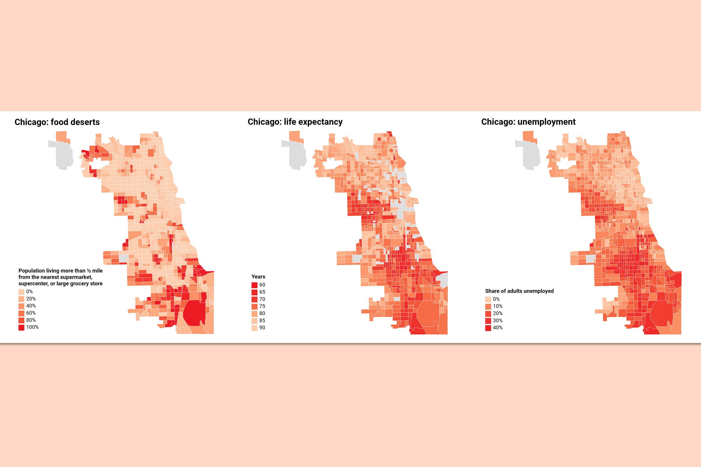
These maps illustrate geographic differences in life expectancy in the three U.S. cities with the largest gaps: Chicago, D.C. and New York. (Note: gray regions of the map are those for which there are no data in the City Health Dashboard.)
Digging a little deeper into Chicago, the city with the nation’s biggest geographical life expectancy gaps, we can see some of the key factors driving those disparities. Chicago is far more racially and ethnically segregated than most U.S. cities—NYU set its “segregation score” at 44.6, well above the national average of 12.6—which the researchers found to be closely linked with lifespan disparity.
Largely black neighborhoods in the Far South Side have some of the city’s lowest life expectancies, and also some of the highest rates of unemployment. Access to fresh food also tends to be lacking in these areas, contributing to higher rates of obesity.
More Must-Reads from TIME
- Why Biden Dropped Out
- Ukraine’s Plan to Survive Trump
- The Rise of a New Kind of Parenting Guru
- The Chaos and Commotion of the RNC in Photos
- Why We All Have a Stake in Twisters’ Success
- 8 Eating Habits That Actually Improve Your Sleep
- Welcome to the Noah Lyles Olympics
- Get Our Paris Olympics Newsletter in Your Inbox
Write to Jamie Ducharme at jamie.ducharme@time.com