One of my favorite features of Google Maps (aside from the killer turn-by-turn directions with lane assist) are the included satellite images. It’s both fun and useful to see the world from a bird’s eye view. The only downside: old government restrictions on just how good those satellite photos could be added unnecessary pixelation and blurring.
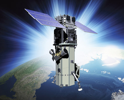
But as technology has changed and improved, so too have the rules. In June, the feds updated their satellite privacy requirements to allow for far more detailed aerial photos. On August 13, DigitalGlobe will launch its WorldView-3 Satellite Sensor to take full advantage, allowing the company to capture features as small as 31 centimeters (just over 12 inches).
The new satellite will be capable of collecting “key features such as manholes and mailboxes,” the company explains.
The WorldView-3 will bring higher resolution satellite photos to Google and Microsoft, both of whom rely on DigitalGlobe for images. Best of all, it shouldn’t take long to see those new images – according to DigitalGlobe, the new satellite is capable of capturing 680,000 square kilometers of photos per day. That would allow the satellite to capture detailed shots of the entire United States in just over two weeks.
To learn more about the next-gen WorldView-3 satellite and the technology behind it, you can visit the Satellite Image Corporation website.
This article was written by Fox Van Allen and originally appeared on Techlicious.
More from Techlicious:
More Must-Reads from TIME
- Biden Drops Out of Presidential Race , Endorses Harris to Replace Him
- Why Biden Dropped Out
- The Chaos and Commotion of the RNC in Photos
- Why We All Have a Stake in Twisters’ Success
- 8 Eating Habits That Actually Improve Your Sleep
- Stop Feeling Bad About Sweating
- Welcome to the Noah Lyles Olympics
- Get Our Paris Olympics Newsletter in Your Inbox
Contact us at letters@time.com