For a show that lasts less than three minutes, the total solar eclipse that will traverse the U.S. on Aug. 21 is already inspiring an impressive level of fervor. Everyone in the U.S. will see at least a partial eclipse, but only those who are privileged to be within a narrow band known as the “umbra” will get to witness a total eclipse, in which the sun is entirely obscured by the moon. Hotels and campgrounds within this celestial highway, which runs from Oregon to South Carolina, are a hot ticket.
This strikes us as unfair, because it’s rare for a total solar eclipse to pass so close to so many Americans’ homes — it’s the first one to be visible from the U.S. since 1979, and back then it just skimmed the upper Northwest before heading to Canada. So we ran a few calculations to see whether there is enough open space within the umbra for every American to theoretically witness the complete eclipse.
Our semi-scientific result: There is actually enough public land and accessible roadways in the eclipse’s path to easily fit every U.S. resident — with room to spare.
To figure this out, we downloaded maps of the eclipse zone from NASA and various geographical maps from government agencies. The continental U.S. is over 3 million square miles, but the land where the total solar eclipse will be visible amounts to about 174,250 square miles.
If you imagine this space to be entirely accessible, some simple back-of-the-envelope math confirms that there’s plenty of room for many billions of people. There are 27,878,400 square feet in a mile — that’s 5,280 x 5,280 — so if you assume each person needs 36 square feet (6 feet in either direction) then you can fit 774,400 people in a square mile. That adds up to 135.7 billion people who could pack into the eclipse space — which happens to be more people than are likely to have ever existed.
But that calculation assumes every homeowner, business and military installation would welcome hordes of people descending on their private property. So our next step was to filter the entire zone down to just public land, using a pair of mapping code libraries to analyze the topology of just the area inside the umbra. (Anyone who wants to see the nitty-gritty of these calculations is can find them on the TIME Labs Github page.)
Fortunately, the United States Geological Survey publishes a National Map that provides detailed data on all federal land. This includes everything from National Parks to Indian Reservations to land designated for military use. To err on the side of caution, we only considered “Public Domain Land,” defined as “A tract of public land owned by the U.S. Government … but not designated for a specific use.”
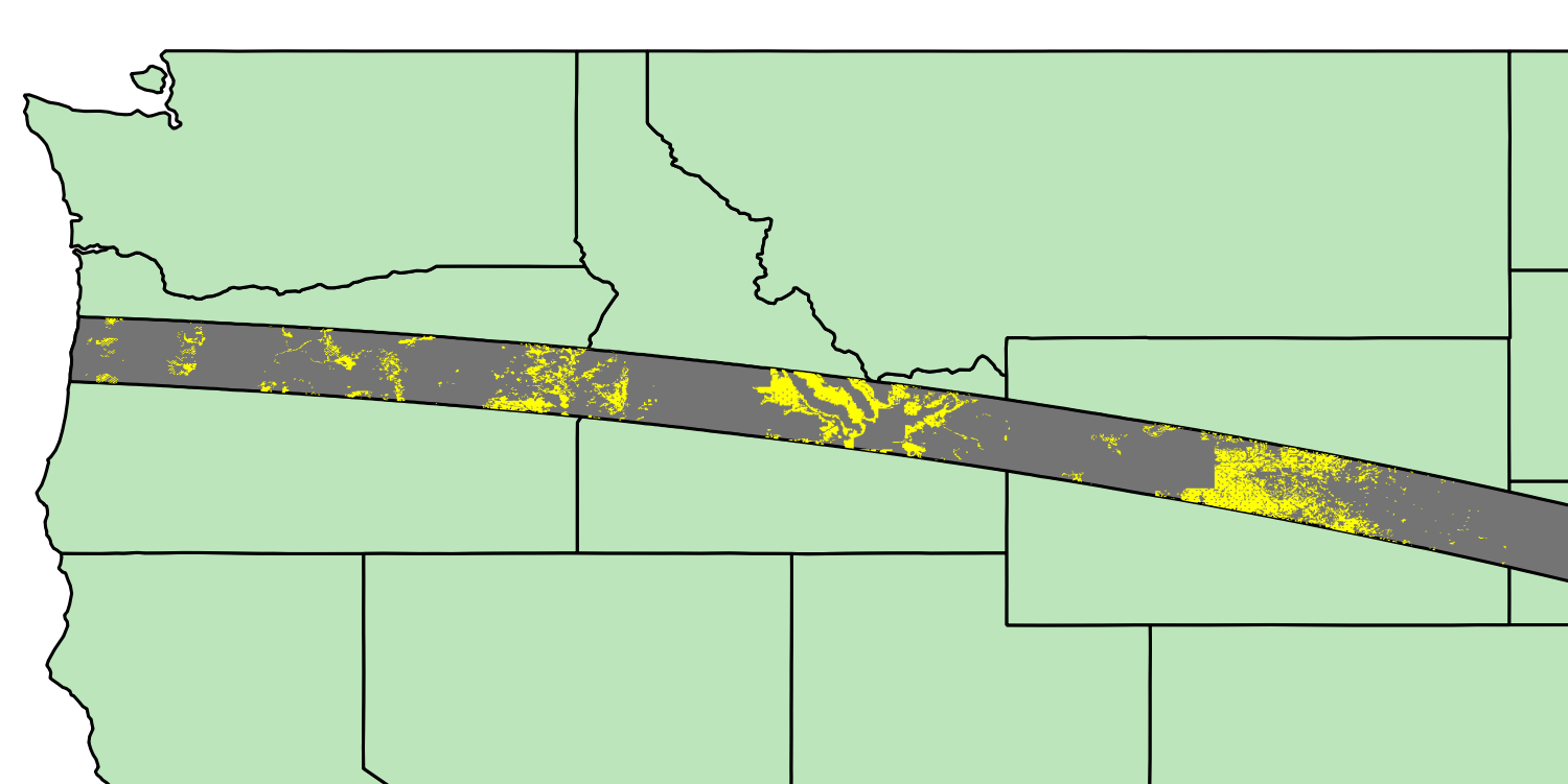
Inside the umbra zone, there are 10,235 square miles of public domain land, located entirely in Oregon, Idaho and Wyoming:

As of July 25, there are 325,517,460 U.S. residents. After reserving 22,500 square feet (150 feet x 150 feet) for portable toilets each mile, you get 27,855,900 available square feet per mile, which comes out to 285.1 billion square feet just in the public domain. Divided by the population, you get 876 square feet per person.
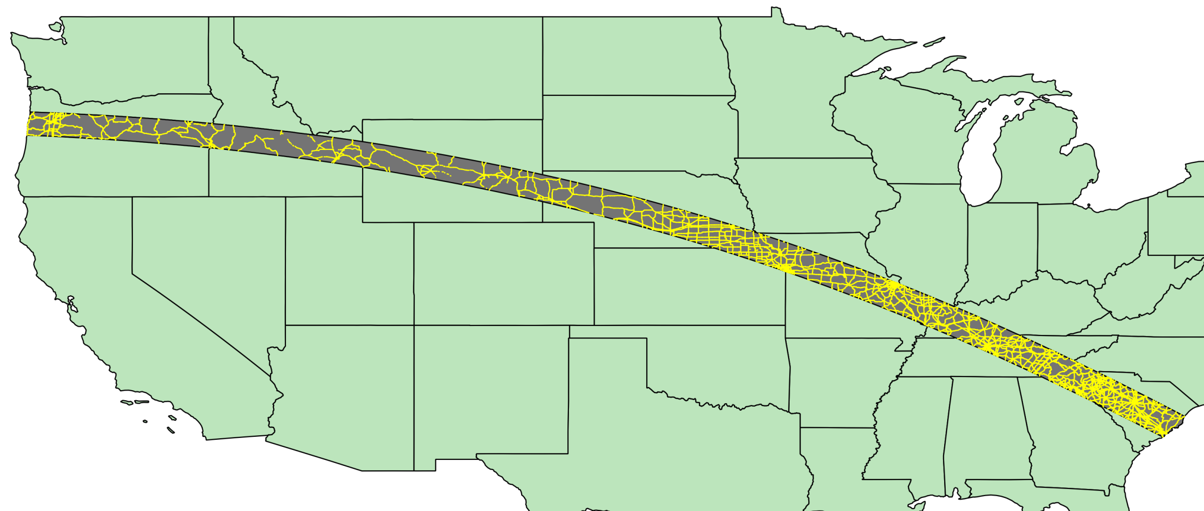
That’s a good start, but something of an inconvenience for everyone to the east. So next, we looked at all public roads that pass through the umbra, using the National Highway Planning Network, a “database that contains line features representing just over 450,000 miles of highways in the United States.” After filtering this down from all major highways and rural arteries to only publicly accessible roads, we found 24,210 miles of roadway in the eclipse zone:

The last step was to decide how many people could fit along the sides of the roads. We allowed for 20 feet per car lining both sides of the road and an average of four people per car. That allows for 12,782,880 cars along the roads (24,210 miles * 5280 feet/mile * 2 sides of the road / 20 feet per car), or 51.1 million people if you assume an average of four people to a car.
If you subtract those people along the roadways, the remaining 274 million people on the public land now get over 1,000 square feet each. And that doesn’t include places like Yellowstone National Park, which could provide a lot more space for the population to spread out even more. If you can get everyone there.
More Must-Reads from TIME
- Why Trump’s Message Worked on Latino Men
- What Trump’s Win Could Mean for Housing
- The 100 Must-Read Books of 2024
- Sleep Doctors Share the 1 Tip That’s Changed Their Lives
- Column: Let’s Bring Back Romance
- What It’s Like to Have Long COVID As a Kid
- FX’s Say Nothing Is the Must-Watch Political Thriller of 2024
- Merle Bombardieri Is Helping People Make the Baby Decision
Write to Chris Wilson at chris.wilson@time.com