Early summer typically marks the start of the dry season across much of the United States. But that’s far from the case across vast swaths of the country this year, a new map from the National Weather Service shows.
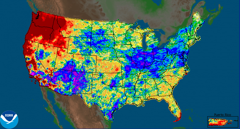
The map compares data collected over the past 30 days from local weather centers with local averages from the same days collected over the past 30 years. Purple and blue regions received at least 1.5 times the average rainfall in the last 30 days — and the map shows large parts of the Northeast and Southwest much wetter than average.
But other regions received very little rain, like drought-stricken California and Washington, which sweated through a heatwave in late June. Very few regions received an average level of rainfall.
Dan Petersen, a meteorologist at the National Weather Service, described the trend as “unusual.” “It’s just been striking—instead of just being part of a season, we’ve had multiple seasons of this trend,” he said.
More Must-Reads From TIME
- The 100 Most Influential People of 2024
- Coco Gauff Is Playing for Herself Now
- Scenes From Pro-Palestinian Encampments Across U.S. Universities
- 6 Compliments That Land Every Time
- If You're Dating Right Now , You're Brave: Column
- The AI That Could Heal a Divided Internet
- Fallout Is a Brilliant Model for the Future of Video Game Adaptations
- Want Weekly Recs on What to Watch, Read, and More? Sign Up for Worth Your Time
Write to Justin Worland at justin.worland@time.com