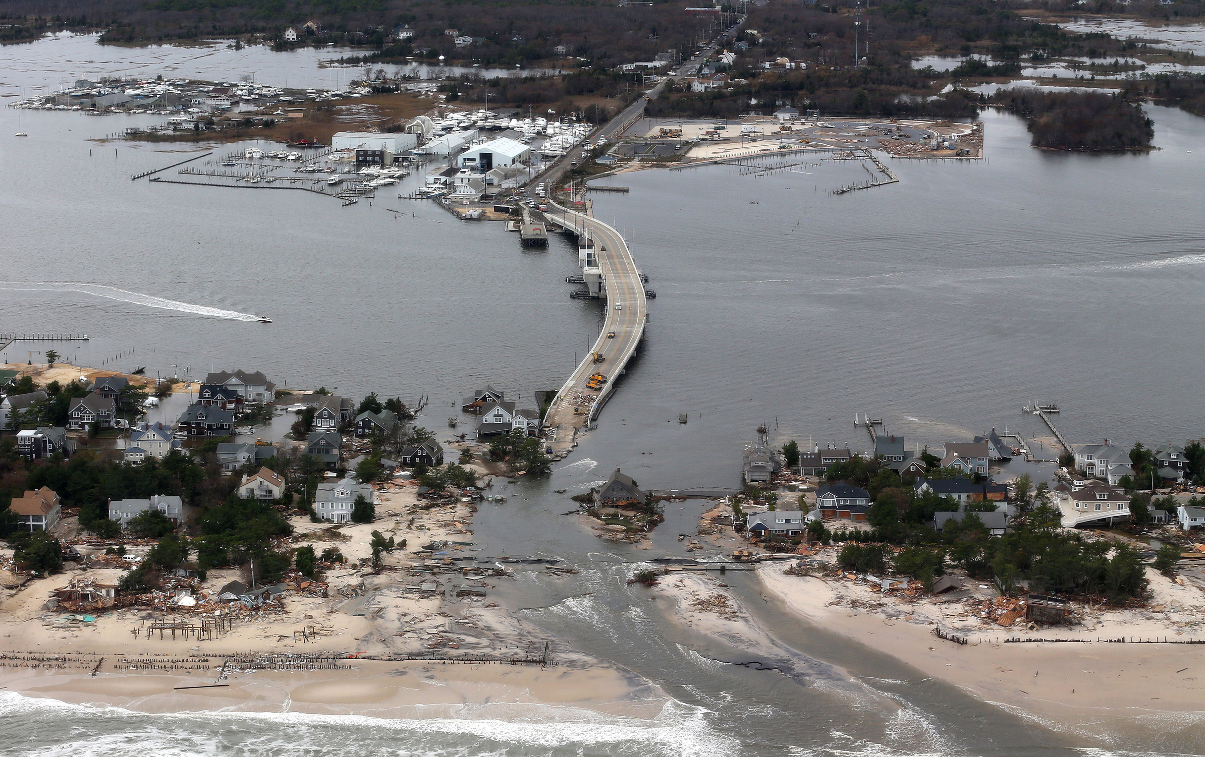
The weather outlook for the low country of South Carolina looked unsettling. Alan Walters, charged with protecting more than 9,000 students as the executive director of safety for the Georgetown County school district there, pored over the forecasts. Just a few weeks into the 2015 school year, he was facing the possibility of a dangerous storm. With computer forecast models literally all over the map in projecting where the storm—soon to become Hurricane Joaquin—would go, Walters was left to weigh the options on his own. The choice, as ever, was between sounding the alarm and sounding unduly alarmed. Closing schools early meant safe kids and freed-up school buildings and buses for evacuation use. But it also could cause unnecessary distress, and deprive low-income students of the breakfast and lunch they would have had at school if the storm didn’t hit. By Thursday, Oct. 1, with heavy rains imminent but no clear picture of whether Joaquin would hit the coast, Walters and the superintendent made a call: no school on Friday.
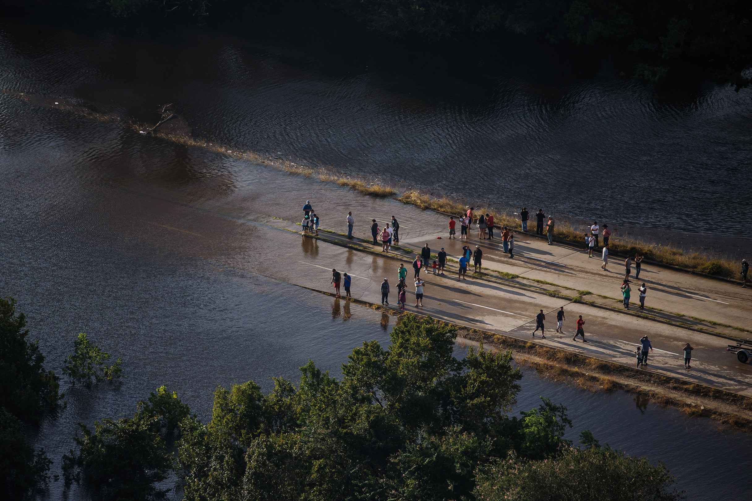
Joaquin veered away but fed massive amounts of moisture to another system hovering over the Southeast. The unusual configuration dumped a staggering amount of rain—more than 20 inches— sending Georgetown County’s five rivers surging over their banks, making roads impassable and isolating communities. Schools remained closed for seven days. “We had to send teachers in by boat, and we commandeered a church for classes,” Walters says. Ultimately, the flooding was blamed for 19 fatalities and nearly $1.5 billion in damages in South Carolina.
So Walters and other officials made the right call, but with little time to spare. The uncertain forecasts had them scrambling, and Walters knows well the risks of crying wolf with an unnecessary alert. Before joining the school district, he was a law-enforcement officer for 17 years and often had to go door-to-door to persuade skeptical residents to evacuate. “We’d hand them a black Sharpie and tell them to write your name and next of kin” on their arm, he says. To keep people safe, he needs a forecast that’s both accurate and early. “We don’t want to be running down to the wire,” he says. “If we can get notice further out, and better probabilities, we can do a lot more preparation. That would be huge.”
In the scientific race to predict dangerous storms, many experts believe the U.S. has fallen behind. In 2012, Europe’s weather center correctly foresaw that Superstorm Sandy would smash into the East Coast even as the U.S. computer model was projecting no landfall. Since then, the relative accuracy of “the Euro model” has only gotten more publicity, putting American weather prowess under scrutiny. The stakes are enormous: from saving lives in severe storms and guiding farmers and manufacturers on key decisions to supporting emerging industries like self-driving cars and delivery drones, meteorology plays a critical, often under-appreciated role in public safety and economic growth. National Weather Service (NWS) figures put the number of U.S. weather-related deaths last year at 508, a figure that doesn’t include unofficial estimates of Hurricane Maria–related deaths in Puerto Rico that range from hundreds to more than 1,000. The cost to the U.S. economy from weather and climate in 2017 (a figure that includes everything from damage to homes to crops wiped out), was estimated at $306 billion by the National Oceanic and Atmospheric Administration (NOAA).

For Walters—and everyone threatened by severe weather—a more accurate forecast means stopping the hemorrhage of lives and money caused by increasingly frequent storms. And up the East Coast in New Jersey, a short drive from the shoreline devastated by Sandy, an unlikely oracle by the name of Shian-Jiann Lin has invented a better way to predict the future.
Lin is a scientist, not a psychic. His crystal ball is a super-computer and a set of mathematical equations; his rituals involve dividing the sky into imaginary boxes and the prognostications he pursues can help millions avoid, or at least prepare for, disaster. The next-generation weather forecast model that Lin and his team at the Geophysical Fluid Dynamics Laboratory in Princeton have devised, called FV3, is about to become a linchpin for U.S. meteorologists.
Louis Uccellini, director of the NWS, describes FV3 as “a major breakthrough” and tells TIME that progress is now ahead of schedule, with the revamped model set to exit testing and become operational in early 2019. The goal: put the U.S. global forecast model back on top in a world being reshaped by climate change. In this summer of extreme events, from brutal heat waves to deadly forest fires, everyone wants to know what the weather will do next.
Lin, 60, works from a corner office at the Geophysical Fluid Dynamics Laboratory, a facility of the NOAA, that looks like an obsessed academic’s lair: a desktop computer screen and a laptop, surrounded by whiteboards covered in equations and a scattering of books.
The appearances belie the immense complexity of Lin’s work. The screen on his desktop is connected to a U.S. Government facility in Oak Ridge, Tenn., where a supercomputer named Gaea, after the Earth goddess of Greek mythology, can perform more than 1,100 -trillion -calculations a second. I watch as Lin types a simple one-line command: “msub C_1536_0801_e76.” Those keystrokes transmit a set of initial parameters to Oak Ridge and instruct Gaea to launch the experimental FV3 model. It will take 80 minutes to complete the full 10-day run of the model. In other words, every eight minutes, it looks one day further into the future.
When Lin shows me some results, I learn a bit of bad news about the Fourth of July holiday that’s a week away. “This is hot,” Lin says, scanning the map. “This is pretty hot.” Indeed, his model has things sweltering in large swaths of the country, a heat wave that did indeed come to pass.
To understand FV3, you first need to know how weather-forecasting models work. First, a computer creates a mathematical picture of the current state of the atmosphere based on real-world observations of air pressure, temperature and moisture from the multibillion-dollar global infrastructure of satellites, radar, weather stations and sounding balloons.
Next, using equations that describe the movement of air, the computer crunches numbers to step forward in time—-calculating what the atmosphere will look like a few minutes in the future. Keep feeding those numbers back into the equations, and you can predict further out in time. It’s all governed by the laws of physics, much the same way a video game can simulate the arc of a basketball thrown across an imaginary court.
What Lin and his team have done is devise a better, more accurate way for the computer to organize that picture of the atmosphere and how it behaves—the so-called dynamical core of the model. While the current American model uses a “spectral model,” where the atmosphere is represented by mathematical waves, FV3 (“Finite Volume on a Cubed-Sphere”) divides the atmosphere into boxes. Each box of air might be a little different in temperature, humidity, pressure and movement. Each box also acts upon the other boxes touching it, and vice versa. This models the atmosphere more accurately.
Lin is proud of this work, and believes that FV3 will significantly up the U.S. meteorology game. “One of our main goals is helping NOAA and the nation have the best forecast humanly possible,” he says. “But it’s certainly a competition around the world.”
America’s lagging prediction model is especially dangerous when you consider that disaster preparedness is as much a psychological exercise as a technological one. The general public now has more access to weather-forecast information than ever before. From weather geeks glued to their smartphone apps to ordinary citizens tuning- in to nonstop cable-TV coverage, there’s surprising awareness of discrepancies between the U.S. and European models-—and experts worry this is leading some amateurs to choose the predictions- they like best and disregard official advice on evacuations and precautions.
Like Walters, emergency–management expert Craig Fugate has struggled to get the public to take American predictions seriously. Fugate, now the chief emergency management officer of One Concern, an artificial-intelligence startup focused on disaster preparation and management, spent nearly eight years running the Federal Emergency Management Agency (FEMA), beginning in 2009, and is perhaps best known for coining the “Waffle House Index” to diagnose the severity of a disaster. (If Waffle House—a chain restaurant known for staying open even in difficult conditions-—is closed, things are really bad.) A onetime paramedic, Fugate served in a number of county and state emergency-management roles before FEMA, including director of the Florida Division of Emergency Management under Jeb Bush.
Fugate still recalls vividly the destruction from Hurricane Charley in 2004. “We’re looking at this little speck of a storm that’s so rapidly changing,” he says. It wound up rapidly intensifying, surprising forecasters by surging to Category 4 just before landfall in Florida. He remembers flying in a helicopter over the devastated areas just afterwards to survey the damage. “You could see right where it went over Orlando,” he says. There were 10 direct fatalities and an estimated $15 billion in damage costs in the U.S.
Better forecast accuracy and a longer lead time would have been vital during Charley. “The more confidence we have, the more we can get people to do things early,” Fugate says. “You’re -willing to make the decisions days out where you can affect the outcome.” When computer models generate conflicting or -low–confidence predictions, forecasters generally must err on the side of safety—that is, they overwarn rather than underwarn. Overpreparation—moving supplies, mobilizing workers for -overtime—is costly, and carries its own variety of danger. “If you cry wolf and nothing happens, that’s a dilemma,” Fugate says. Fuel public distrust of forecasts, and more lives could be lost.
The constant comparisons with the European model obscure the fact that U.S. weather forecasting is remarkably good—and getting better all the time. In fact, our ability to forecast the weather at this level of accuracy could easily rank as one of the great scientific achievements of the past century.
Take the daily NWS forecasts for high and low temperatures, for instance. One-day forecasts-—the temperatures expected tomorrow—from the past few years are off by only 2°F to 3°F. In 2017, a five-day forecast had the same level of accuracy as a three-day forecast from 15 years ago. Our ability to look further into the future is consistently expanding.
Even statistics like those don’t reflect the real-world impact from forecast improvements. When some 4,000 of the nation’s meteorologists and weather professionals gathered at an annual meeting in Austin earlier this year, they commemorated something of a milestone: despite the historic nature of the 2017 hurricane season, the death toll in Texas (from Harvey) and Florida (from Irma) was surprisingly low, below 100 in each case.
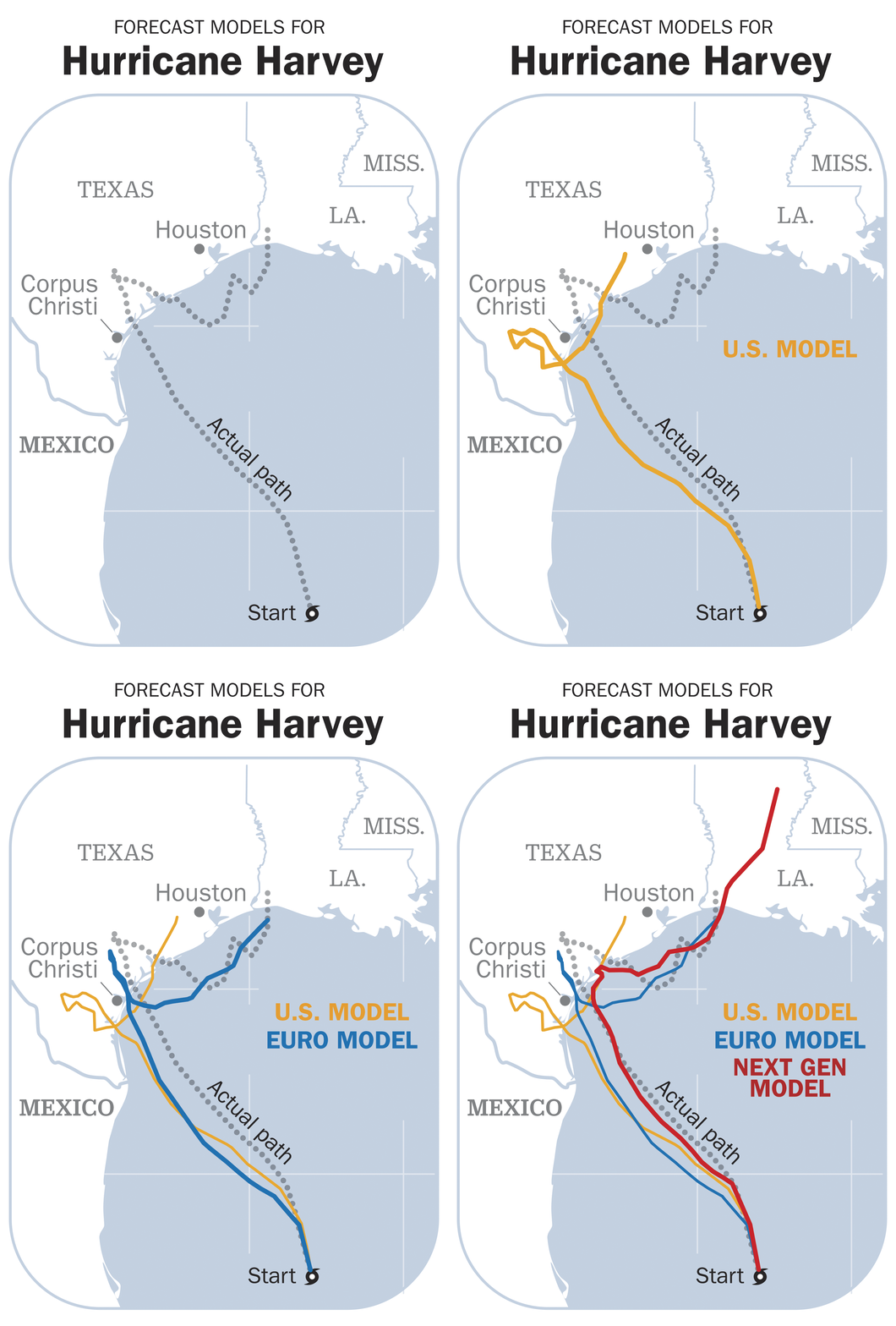
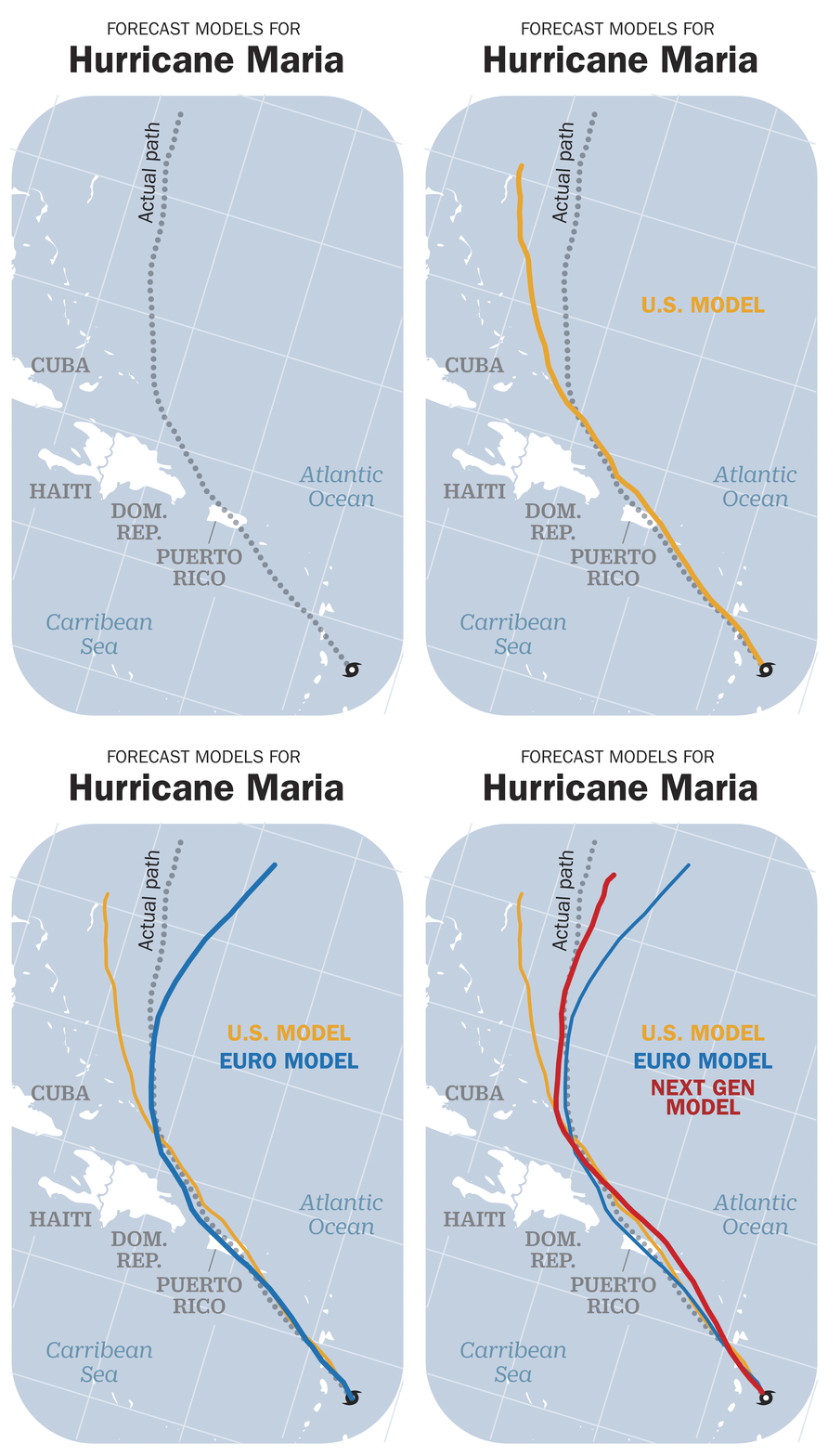
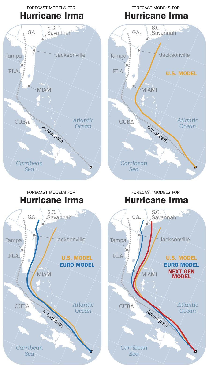
These victories weren’t simply a matter of accurately projecting the track of the devastating storms. They also underscored growing confidence in forecasts’ reliability. Emergency officials are now willing to activate response plans well in advance. (The path of Hurricane Maria, experts say, was well forecast; the fatalities in Puerto Rico are more indicative of the -difficulty of evacuating on an island and the woefully insufficient disaster response.)
In the case of Irma, Florida Governor Rick Scott was persuaded to declare a state of emergency six days before the storm’s predicted landfall, when it was still more than 1,000 miles away. “Our confidence level is building to the point where we can actually start talking about the potential storm system as a hurricane even before it develops,” says Uccellini, the NWS director. “We were actually preparing for Irma … while it was still a wave coming off of Africa.”
In 1997, 48-hour forecasts of hurricane tracks were off an average of 150 nautical miles. Last year, the track error was down to 56 miles. And the cone of uncertainty, familiar now to most from hurricane–forecast maps, has been shrunk by 15% from five years ago and more than 30% from 10 years ago.
Despite all of that progress, Superstorm Sandy was a wake-up call for U.S. weather forecasters. The European model’s superiority at forecasting the superstorm’s path in 2012 shook up the weather community. When Congress approved additional budget in the aftermath, it included some $80 million in supplemental funding for the NWS, largely to pay for expanded super-computer capacity to improve the performance of the computer models. NOAA and the weather service also launched an effort to overhaul the main model itself—a process that led to the selection of FV3 as the new dynamical core.
Some weather experts say the U.S. still isn’t doing enough to get better. Cliff Mass, a professor of atmospheric sciences at the University of Washington, is one of the best-known and most outspoken critics of the NWS. He panned -NOAA’s decision to select Lin’s approach for the model and says the nation’s weather research and forecasting, spread among centers across the country, is too diffuse, in sharp contrast with the tightly focused work by the European Centre for Medium-Range Weather Forecasts. “The Europeans work together,” Mass says. “They have an organized, strategic way of doing this.”
Now that NOAA has locked in Lin’s model, Mass wants to see a commitment to ongoing improvements—a sentiment shared by Lin himself. “The way you catch up to the other guys,” Lin says, “is to keep improving faster than them.”
There are advances underway well beyond computer-model upgrades, and in many cases the U.S. defines the cutting edge. GOES-16, a new weather satellite that was launched in 2016 and became operational late last year, is providing unprecedented imagery of storms and the atmosphere, and can even observe lightning from space, which can help improve tornado-warning lead times. (A sister satellite launched this year, GOES-17, is now in a testing phase and has suffered some technical problems, but is also sending back astounding views.)
NOAA expects to eventually improve the reliability of forecasts 30 days out, and even advance overviews of the entire hurricane season. On May 24, NOAA issued its 2018 Atlantic hurricane–season forecast, predicting a 70% chance of 10 to 16 named storms, of which five to nine could become hurricanes, including one to four major hurricanes-—a near or above-normal outlook.
With the first day of school just a few weeks away, Alan Walters is keeping a close eye on those outlooks back at his Georgetown County schools office. “The more notice we can get, the better,” he says. He just hopes that, whether those storms require a cancelled football game or mass evacuations, the families of South Carolina heed the warnings.
- Donald Trump Is TIME's 2024 Person of the Year
- Why We Chose Trump as Person of the Year
- Is Intermittent Fasting Good or Bad for You?
- The 100 Must-Read Books of 2024
- The 20 Best Christmas TV Episodes
- Column: If Optimism Feels Ridiculous Now, Try Hope
- The Future of Climate Action Is Trade Policy
- Merle Bombardieri Is Helping People Make the Baby Decision
