El Niño—the natural climate phenomenon of warm temperature in the Pacific Ocean—has officially begun, and it’s sure to affect weather patterns globally in conjunction with climate change.
On Thursday morning, the National Oceanic and Atmospheric Association (NOAA) announced that El Niño conditions were present and that its strength is expected to gradually increase throughout the year, into 2024. Climate analysts track the Pacific Ocean’s temperatures meticulously and declare a period of El Niño once temperatures near the equator are at least 0.9 degrees Fahrenheit above historical averages for three consecutive months.
Scientists have been anticipating El Niño for months, while also expressing concern over how it may exacerbate the effects of climate change. The extended period of warmth in the Pacific Ocean leads to higher global temperatures, and can impact weather patterns, ecosystems, and economies.
“The ocean does a very good job of holding heat,” Alex DaFilva, a meteorologist at AccuWeather, says. “It can release some of that heat and cause global temperatures to be a little bit warmer. This year is probably going to be in the top five years for global temperatures, I think.”

Why does El Niño occur?
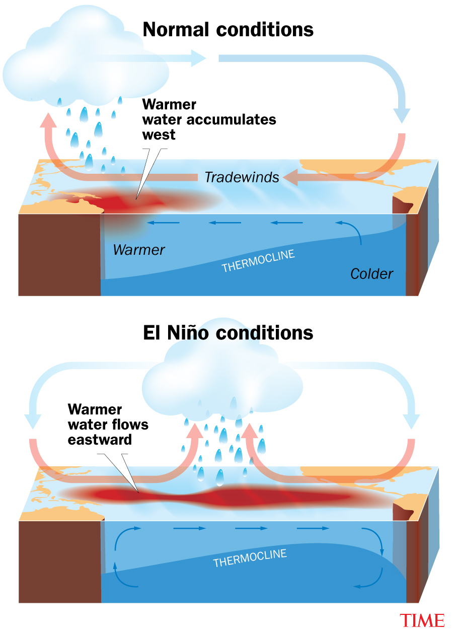
In the Pacific Ocean under standard conditions, trade winds—wind patterns that blow horizontally along the equator—travel east to west bringing warm water from South America towards Asia. At regular speed, the trade winds cause ample wave movement, allowing the warm surface water and the deeper cold water to mix in the ocean.
But when the trade winds slow down, wave movement drops and the stillness halts water from mixing as much. “It doesn’t take much as soon as those winds weaken,” DaFilva says. The ocean’s temperature quickly warms up, leading to an episode of El Niño.
Read more: How El Niño May Test the Limits of Our Climate Knowledge
How long is it expected to last?
El Niño usually occurs every two to seven years, more frequently than its opposing climate phenomenon, La Niña, but neither follows a schedule.
El Niño typically lasts nine to 12 months, but can sometimes carry on for years. Experts predict that this year, El Niño is likely to continue through the summer, fall, and winter. “There are some computer models that are indicating that it might even go into later next year,” DaFilva says. The last period of El Niño spanned several months from late 2018 to mid-2019.
What El Niño means for extreme weather
For Canada and the northern U.S., El Niño usually brings warm, dry weather—a worry for Canada’s already abnormally hot spell this year and the ravaging wildfire crisis. The southern U.S. is prone to more storms during El Niño, posing a threat to exacerbate the heavy rain the region has been experiencing. Flash floods and overloaded infrastructure issues have plagued some southern states in recent months.
One perk may be that during times of El Niño, the Atlantic coast tends to grapple with fewer hurricanes. However, with climate disruption causing warmer oceans overall, some scientists encourage preparation for a potentially strong hurricane season this summer anyways.
The rise in severe weather events has been linked to human activity disrupting the Earth’s climate and increasing the global temperature. The three hottest years on record so far have been 2016, 2019, and 2020, two of which saw periods of El Niño.
“[This] could be the warmest year on record,” DaFilva says. “I’m not sure, it’s just gonna depend on how strong El Niño gets.”
More Must-Reads from TIME
- Caitlin Clark Is TIME's 2024 Athlete of the Year
- Where Trump 2.0 Will Differ From 1.0
- Is Intermittent Fasting Good or Bad for You?
- The 100 Must-Read Books of 2024
- Column: If Optimism Feels Ridiculous Now, Try Hope
- The Future of Climate Action Is Trade Policy
- FX’s Say Nothing Is the Must-Watch Political Thriller of 2024
- Merle Bombardieri Is Helping People Make the Baby Decision
Contact us at letters@time.com