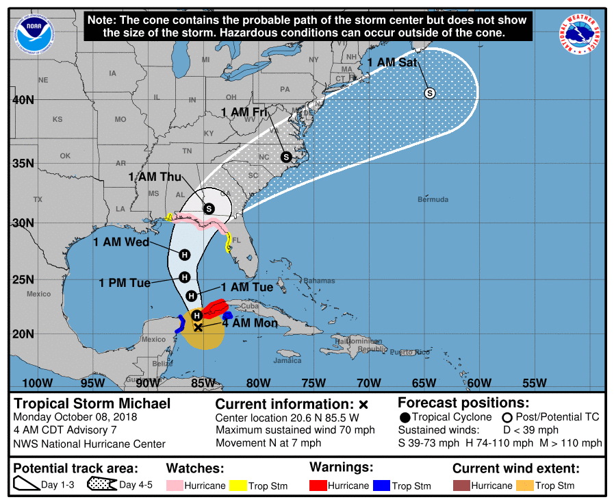
Tropical Storm Michael will soon become Hurricane Michael as it moves north toward Florida, the National Hurricane Center said Monday morning.
As of 5 a.m. ET, Tropical Storm Michael is about 90 miles east of Cozumel, an island off Mexico’s east coast, and 100 miles west of Cuba. It is moving north at a speed of around 7 m.p.h. It’s expected to speed up slightly through Tuesday night as it passes between Mexico and Cuba, before tacking northeast on Wednesday and Thursday.
The following NOAA graphic shows the likely path of Hurricane Michael’s center (it does not show the estimated size of the storm):

A hurricane watch is in effect along the Alabama-Florida border down to the Suwanee River. Hurricane conditions are expected within the next 12 hours, according to the NHC. Parts of the Florida panhandle near Pensacola down to Anna Maria Island, including Tampa Bay, are under storm surge watch.
What’s expected to become Hurricane Michael is forecast to dump between 4 and 8 inches of rainfall on parts of the Panhandle and the Big Bend with isolated downpours of up to 12 inches, potentially causing life-threatening flash floods.
Florida Governor Rick Scott has issued a state of emergency for 26 counties. “This storm will be life-threatening and extremely dangerous,” he told reporters on Sunday after receiving a briefing at the State Emergency Operations Center.
Cuba’s government has also issued a hurricane warning for the province of Pinar del Rio.
More Must-Reads from TIME
- Cybersecurity Experts Are Sounding the Alarm on DOGE
- Meet the 2025 Women of the Year
- The Harsh Truth About Disability Inclusion
- Why Do More Young Adults Have Cancer?
- Colman Domingo Leads With Radical Love
- How to Get Better at Doing Things Alone
- Michelle Zauner Stares Down the Darkness
Write to Ciara Nugent at ciara.nugent@time.com