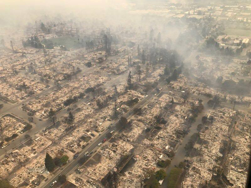
More than a dozen wildfires have devastated Northern California this week, laying waste to 1,500 buildings, injuring more than 100 and claiming ten lives. Inflamed by powerful winds, fourteen wildfires broke out overnight Sunday and wracked the Napa and Sonoma Valleys Monday, displacing thousands of northern California residents. Two hospitals in Santa Rosa have had to evacuate patients, and the death toll is expected to rise as the trail of devastation grows in what is already one of California’s ten most deadly fires.
The Santa Rosa neighborhood of Coffey Park was among the worst hit area, according to Business Insider, which published before and after images of the area in all their stark contrast. The residential subdivision, built in the 1980s and home to about 8,000 residents, according to the San Francisco Chronicle, appears to have been completely razed. Aerial photos showed the neatly manicured neighborhood, with single-family homes clustered on tree-lined streets reduced to ash, with trails of smoke rising over a scorched, dystopian landscape.
An estimated 20,000 people were evacuated because of the blaze, the Associated Press reports, while four of the six shelters operating in Santa Rosa are at capacity, according to the Santa Rosa Fire Department.
More Must-Reads from TIME
- Introducing the 2024 TIME100 Next
- The Reinvention of J.D. Vance
- How to Survive Election Season Without Losing Your Mind
- Welcome to the Golden Age of Scams
- Did the Pandemic Break Our Brains?
- The Many Lives of Jack Antonoff
- 33 True Crime Documentaries That Shaped the Genre
- Why Gut Health Issues Are More Common in Women
Write to Eli Meixler at eli.meixler@time.com