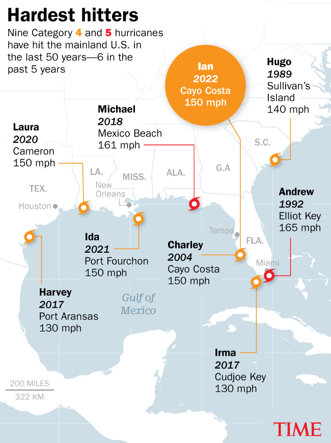
Hurricane Ian, which peaked as a Category 4 storm in the Gulf of Mexico, hammered Southwest Florida this week, flooding the coastal areas around Fort Myers, leaving millions of people without power, and causing an unknown number of deaths. Ian lost some of its intensity as it crossed the state, but began regaining strength over the Atlantic, before veering back inland to slam Georgia and the Carolinas.
Ian is doing what all tropical cyclones are known to do: build up energy when there is a warm water source to pull from. Which is why these types of storms, also known as typhoons or hurricanes, benefit from global warming. Over decades, greenhouse gasses like carbon dioxide have been building up, absorbing heat that is causing temperatures in both the atmosphere (which holds more water vapor when heated) and the oceans to increase. That warming effect is like a performance enhancer for cyclones, giving them optimized fuel to strengthen and then devastate whatever lies in their paths.
One PNAS study from 2020 found that, as of 2017, about 38% of the planet’s tropical cyclone activity reached major intensity (that is, a Category 3, 4, or 5). For North Atlantic hurricanes specifically, the rate was similar at 42%. But those rates have been ticking up over time—particularly in the North Atlantic.
As the below chart shows, it’s 24% more probable today that a cyclone on planet earth will be at major intensity compared with four decades ago. In the North Atlantic, it’s about 260% more probable.
In other words, the likelihood that Ian would be a Category 3 storm or greater was around three times higher than if it had formed back in 1980. While global warming has a lot to do with that uptick, there are other factors at play that contribute to regional differences, says Jim Kossin, senior scientist with The Climate Service, an S&P Global Company, and co-author of the paper.
“In addition to greenhouse gasses, which are uniformly mixed around the world, the Atlantic has also had a reduction in pollution aerosols,” Kassin says. “Some of that is a reduction of Saharan dust in the last 40 years,” he explains, referring to the evidence that hotter sea surface temperatures are weakening trade winds from Africa that transport the dust. “And some of it is a reduction in sulfate pollution from industry, after the Clean Air Act passed in the 1970s.”
Read more: See the Devastating Toll of Hurricane Ian in Florida
Effectively, smoggy airborne particles like dust, soot, and sulfates act like an umbrella, dimming the sun’s rays. That cooling effect counteracts some of the heating effects from global warming. As air pollution levels around North America and Europe have dropped, that pollution umbrella has thinned, allowing more sunlight to reach—and warm—the surface in these regions.
To determine how much storm intensity has increased over four decades, Kossin and his co-authors relied on track position data, adjusted using satellite imagery (hence why his analysis goes back to 1978, when there were a sufficient number of weather satellites). They dimmed the resolution on the more recent images in order to compare them against early images, and control for the improved hurricane tracking and measuring technology over time.
Because the position data stretched over the lifetime of each storm, the researchers could see not just the peak intensity of the storm, but also intensity duration along the storm’s path. That method provided a more accurate characterization of each cyclone season than simply counting the number of storms that were Category 3 or more, because hurricane categories are based on maximum sustained near-surface winds, without regard to whether those winds lasted for minutes, hours, or days.
Read more: Yes, Climate Change Is Making Storms Like Hurricane Ian Worse
While the data end in 2017—the most recent available at the time of the analysis—it’s likely that the overall trends have continued, or have become even stronger in the years since, says James Done, a project scientist at the National Center for Atmospheric Research who was not involved in the original study, but who has relied on the underlying data for his own published research on tropical cyclone intensity.
Kossin agrees that today’s trends are likely consistent with his findings, particularly when looking at the global picture. With North Atlantic activity, though, it’s harder to extrapolate out as far into the future, he says. That’s partly because, since the 1970s, hurricane intensity in the region has soared due to both the increase in greenhouse gasses and the loss of pollution. Once the air is clean enough that pollution reduction is no longer a factor, North Atlantic hurricane intensity will be largely driven by one big question: how much greenhouse gas we choose to emit.
More Must-Reads From TIME
- The 100 Most Influential People of 2024
- The Revolution of Yulia Navalnaya
- 6 Compliments That Land Every Time
- What's the Deal With the Bitcoin Halving?
- If You're Dating Right Now , You're Brave: Column
- The AI That Could Heal a Divided Internet
- Fallout Is a Brilliant Model for the Future of Video Game Adaptations
- Want Weekly Recs on What to Watch, Read, and More? Sign Up for Worth Your Time
Contact us at letters@time.com