
It wasn’t long after Ferhad Ahma started to speak that the pharmacist in the northeast Syrian city of Qamishli picked him for a foreigner. The Syrian Kurdish humanitarian worker had been living in Germany for 25 years, but his Kurdish was impeccable and he was surprised he stuck out. In fact, it was not Ahma’s accent but his symptoms that gave him away, the pharmacist told him. The black gunk clogging his nose, his difficulty breathing, his trouble sleeping: they were all complaints common to new arrivals to the city, whose bodies had yet to grow accustomed to the area’s toxic pall.
The Syria Ahma remembered from childhood was different. The northeastern governate of Hasakah where he grew up sits within the Fertile Crescent, sometimes known as the “cradle of civilization.” Its golden fields provided about one-third of Syria’s entire wheat production before the war, according to government figures from 2007. But on Ahma’s most recent trip in summer 2019, he saw farmland tarred with crude, cities choked in smoke, and rivers swirling with pollution from backyard oil refineries built and operated by civilians. By the time he got to Qamishli, a good 60 miles away from where the concentration of makeshift oil refineries is highest, he had gotten sick.
“The streets are so dirty and the sky is so dark, it’s not the normal color,” he tells TIME by telephone. “Everywhere, there’s the smell of fuel. Oil.” As he took the medicine the pharmacist handed over, Ahma wondered whether he could ever justify bringing his daughter to see his homeland.
From the dioxin-laced soils of Da Nang to the scorched oil fields of Kuwait, the toxic legacy of conflict can be just as deadly as battlefield violence. On March 15, the war in Syria turned 10 years old, a grim milestone with a devastating humanitarian cost. Yet there have so far been few serious attempts to understand the environmental toll the conflict has taken on the country. An upcoming report by Netherlands-based NGO PAX, expected to be published in the first week of April, seeks to change that.
Read more: Our Last, Best Chance to Save the Planet
Using satellite imaging, geo-location, and other remote sensing techniques, as well as field research and interviews with communities and officials, PAX has documented four major factors that contribute to environmental degradation in northeast Syria—makeshift oil refining, solid waste accumulation, fires, and water supply issues—and aims to provide a starting point to restore habitability. In a separate upcoming report focused on northwest Syria, the group has tracked the disappearance of a quarter of Syria’s forest coverage since 2010.
“People want to return. They want to live on the land and work in their villages and towns,” says the report’s author Wim Zwijnenburg, a project leader for PAX whose research focuses on the intersection of environment, peace, and security. “But what we get from the data we’ve collected is that the pollution and the concerns over health risks are driving people away: they feel unsafe and there’s no money to be made because the yields from the land are so low.”
Ahma felt that keenly on his most recent visit home. PEL Civil Waves, the NGO he co-founded to promote youth empowerment and dialogue between different ethnic,religious, and social groups in northeast Syria, has six offices across the country’s northeast. In community dialogue sessions held in the cities of Qamishli, Hasakah, and Raqa—and in rural provinces and camps for internally displaced people—the war’s toxic effect on the environment would come up again and again, he says.
Parents complained to Ahma that their children were becoming sick more frequently, or got tired after just a short amount of exercise, he says. Those who could leave had done so, but thousands more had no option but to continue working land they knew was poisoning them. Tea—drunk throughout the day in Syria—no longer looked nor smelled like tea but instead resembled Coca-Cola. “The water is so dark that it’s not really water,” says Ahma.
How conflict can pollute
The humanitarian crisis in Syria cannot be overstated. Since the war began, hundreds of thousands of people have been killed and more than half of Syria’s population has either been internally displaced or forced to flee the country. The currency has crashed and even in government-controlled areas, the economy has unraveled in the wake of U.S. imposed sanctions, and Lebanon’s financial collapse. A UNICEF report released March 10 found that as a result of violence, economic crisis, and COVID-19, 90% of Syrian children need support—a figure the UN agency for children says has risen 20% on last year’s number.
But there ought to still be space to consider environmental damage, Zwijnenburg says.
Although people’s immediate safety and security should come first, framing the environment as merely “saving trees, bees and butterflies” is misguided, he says. In fact, knowing how and where conflict is impacting the environment is vital for humanitarian reasons too: from where to set up internally displaced people’s camps to how to allocate resources to enable people to rebuild their lives sustainably.
Charting environmental degradation in most areas of Syria was not possible until recently. The security situation makes gathering data on the ground impossible in many regions. In government-controlled areas, it’s almost impossible for independent civil society groups to operate; and there are limitations on the UN’s ability to access areas outside of government control: like the self-declared Autonomous Administration of North and East Syria—sometimes known as Rojava—where PAX’s upcoming report is focussed.
It was the work of Bellingcat founder Elliot Higgins that first brought popular attention to how open-source information like satellite images and social media uploads could be used to investigate war crimes. As earth observation data started becoming more widely available to the public around 2015, Zwijnenburg—who also contributes to Bellingcat—wondered whether similar methods could chart environmental changes in Syria.
Read more: How Bellingcat Has Exposed War Crimes in Syria and Unmasked Russian Assassins
Sometimes it was a simple matter of using satellite images to track shrinking forests, algae bloom in the Hasakah lake reservoir or the wildfires that scorched thousands of hectares of forests and fields in October. But other environmental impacts required more digging. “If a bomb explodes, someone’s leg is blown off: you can see the effect. But environmental impacts are much less visible,” Zwijnenburg says. “If a factory targeted, can we use that image to locate where the factory is? Can we find out what chemicals were stored in that factory? What’s the risk for people living nearby? And can we use satellite imagery to visualize that?”
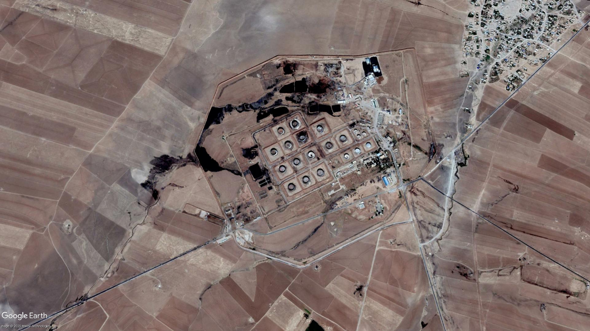
Makeshift oil refineries are among the largest contributors to pollution in Syria. In an attempt to prevent ISIS from gaining access to such an important revenue source, American and then Russian airstrikes took northeastern Syria’s main oil infrastructure offline. But makeshift refineries sprung up in their place, operated by civilians and often controlled by armed groups or criminal gangs. Those refineries heat crude to produce a low-quality fuel called mazut, which is sold on the black market to power stoves, cars, and motorcycles. Civilians working at the refineries, who are often children, are exposed to noxious fumes from manually heating crude and spills, leaking pipes and explosions are common. Vast quantities of crude from wells and storage facilities leak into rivers and groundwater, Zwijnenburg says.
Satellite imagery collated by his team shows that between 2013 and 2017, there were 330 clusters of makeshift refineries across the self-administered region—comprising somewhere between 10,000 and 15,000 refineries of varying sizes. After a crackdown on makeshift refineries by the U.S.-backed Syrian Democratic Forces (SDF) there about 20 clusters still operating today.
Ten years of destruction
On top of oil waste, the region produces hundreds of tonnes of solid waste—household trash, industrial debris, and medical waste like PPE—per day, Zwijnenburg says, but limited financial resources and bans on the import of technical equipment mean there are few options for its disposal. Most ends up piled dangerously at makeshift landfills—whose growth the PAX report also tracks—causing black leachate to leak into the groundwater, lakes, and rivers. Some of that waste is burned without proper incinerators, prompting complaints from local communities over air pollution. Tax revenues collected by the SDF are mostly directed towards security; defending against Turkish incursions into northeast Syria, and also battling insurgents loyal to ISIS.
That insurgency has also exacted a devastating toll on Syrian cropland. PAX’s report lays out in heartbreaking detail the way environmental factors and conflict have exacerbated food insecurity in Syria’s breadbasket region. After years of drought, heavy rains were forecast to bring bumper harvests in the summer of 2019. But flooding spread oil-contaminated water over the wheat fields; it also accelerated the growth of low-lying weeds that would help fires to spread. That summer, some 20,000 acres of wheat and barley were lost to fires across Syria, according to figures released by the government.
ISIS claimed responsibility for setting these and urged its followers to do the same. “The harvest season is still long, and we tell the soldiers of the Caliphate: you have before you millions of dunams of land planted with wheat and barley, which are owned by apostates,” the jihadist groups said in the June issue of its al-Naba newsletter that year, according to a translation by the SITE Intelligence monitoring service.
Read more: How Climate Change Helped Drive a Surge of Migrants to Europe
But ISIS did not set all the fires, says Zwijnenburg. After unhealthy conditions and low yields led many farmers to sell off their assets, those that remained were forced to adopt bad land management practices like stub burning. Incursions by a coalition of armed groups backed by Turkey in 2019 and 2020 also corresponded with spikes in crop fires, PAX’s imaging found. In addition, Turkey-backed armed groups shut down access to pipeline water dozens of times over a period of six months, cutting off access to clean water for hundreds of thousands of people on each occasion. According to recently released figures from the U.N., the price of an average Syrian family’s weekly food basket has risen by 230% in the past year.
The extent to which climate change factored into the outbreak of the Syrian War is much debated—and it should not detract from the fact that Assad’s government began killing protesters. Some analysts have argued that Assad’s mismanagement of the devastating drought Syria faced between 2006 and 2010 heaped pressure on Syria’s rural working-class Sunni population and contributed to rural to urban migration that set the stage for widespread dissent in 2011. More recent scholarship argues that the role of climate change as a threat multiplier was overstated.
Either way, there can be no doubt the war makes it more difficult for Syria to deal with climate challenges: from weak governance and lack of environmental infrastructure to the destruction of forests that act as carbon sinks.
The river of death
Ibrahim Al-Jassim’s wife is one of several women in Tal Mashhan village to have suffered a series of recent miscarriages. The poor medical facilities in the eastern Hasakah province community make it impossible to conclusively establish the cause but, like other health issues that have arisen recently in the community, Al-Jassim thinks it’s because of the area’s worsening pollution. He and his friends call the Gir Zero river that runs through their village and 30 others nearby “the river of death.” In 2019’s heavy rains, the river’s contaminated waters inundated farmland surrounding its banks.
“My wife and I became afraid to bear children, due to our fear that we might have a child with congenital malformation after a number of similar cases appeared in the village,” Al-Jassim, says in a testimony collected by PEL Civil Waves in early 2020, which is using a pseudonym to protect his identity. A June 2020 report by PAX used satellite images to show how persistent pollution from a degrading oil facility has led to tens-of-thousands of barrels of oil flowing into canals and creeks and ending up in the 100-mile-long river.
The Gir zero River has long been a dumping site for oil industry waste. Elders in the area say that farmers stopped using its waters to irrigate their crops in the 1980s when an oil company began operating upstream. Still, after the war, pollution became far worse. Al-Jassim says that it’s now possible to discern how far somebody lives from oil refineries “from the nature of their faces,” sheep fleeces have greyed and chickens’ eggs have darker-colored shells. He and other villages organized a demonstration and a social media campaign to have the makeshift refineries that had mushroomed in Tal Mashhan removed. It was successful, but many others remain upstream. “Like most villagers, I live in constant fear of the impact of this pollution on us,” he says in his testimony, adding that many people have been forced to join armed groups because they can no longer work the land. “If I had the chance to live somewhere else, I would not hesitate to leave immediately.”
Al-Jassim’s story is just one of hundreds that PEL Civil Waves’ local representatives collected in late 2019 and early 2020, says Ahma. But as abject as these accounts are, he says he has been struck by the enthusiasm of young people to help remediate their communities. After PEL Civil Waves organized a competition in 2020 calling for project proposals that would examine the impact of the environment on social cohesion, Ahma says he received about 20 baseline environmental studies from youth groups in cities, towns, and villages across the northeast.
For Zwijnenburg, that’s an exciting prospect. As much as advances in remote sensing technology have made mapping environmental changes more possible, data collected on the ground is integral to creating a fuller picture. Medium resolution satellite images can show how far a dangerous informal landfill has spread, for example, but they are less effective at showing how high its garbage is piled or how soon heavy rains might collapse it.
This month, Zwijnenburg had planned to travel to northeast Syria to host a training program in collaboration with PEL Civil Waves. It would provide local youth groups with air, earth, and water quality monitoring tools and teach them how to gather and record data on the environmental changes they’ve observed in their communities. The pandemic has meant that the training program will be online for now, with a view to running future courses when travel becomes more possible. It’s an important first step towards addressing a long-neglected issue, Ahma says: “We realized we are not alone.”
More Must-Reads From TIME
- The 100 Most Influential People of 2024
- The Revolution of Yulia Navalnaya
- 6 Compliments That Land Every Time
- What's the Deal With the Bitcoin Halving?
- If You're Dating Right Now , You're Brave: Column
- The AI That Could Heal a Divided Internet
- Fallout Is a Brilliant Model for the Future of Video Game Adaptations
- Want Weekly Recs on What to Watch, Read, and More? Sign Up for Worth Your Time
Write to Joseph Hincks at joseph.hincks@time.com