The high ground of space often makes the Earth’s grandest features shrink to invisibility. You can’t really see the great Wall of China from orbit—at least not with the unaided eye. You certainly can’t see Hoover Dam or the Empire State Building or Beijing’s sprawling Forbidden City. But you can see nature—both at its magnificent best and its terrifying worst.
That’s the case with the wildfires that are currently blowtorching their way through southern California. The Ventura County fire is now twice the size of Washington, D.C. Nearly 23,000 homes and businesses are threatened and 260,000 people have been evacuated—the equivalent of the population of St. Petersburg, Fla. A decade of drought and powerful Santa Ana winds are being blamed for the disaster.
Multiple satellites, along with astronauts aboard the International Space Station, have been monitoring the hellscape below from the cold and quiet of space. Here are just a few of the images they’ve returned.
Tuesday, Dec. 5
![On Dec. 5, 2017, the Multi Spectral Imager (MSI) on the European Space Agency’s Sentinel-2 satellite captured the data for a false-color image of the burn scar in Ventura County, California. Active fires appear orange; the burn scar is brown. Unburned vegetation is green; developed areas are gray. The Sentinel-2 image is based on observations of visible, shortwave infrared, and near infrared light.The fires mainly affected a forested, hilly area north of Ventura, but flames have encroached into the northern edge of the city. On December 6, 2017, Cal Fire estimated that at least 12,000 structures were threatened by fire.Powerful Santa Ana winds fanned the flames. Forecasters with the Los Angeles office of the National Weather Service warned that the region is in the midst of its strongest and longest Santa Ana wind event of the year. They issued red flag warnings for Los Angles and Ventura counties through December 8, noting that isolated wind gusts of 80 miles (130 kilometers) per hour are possible.A prolonged spell of dry weather also primed the area for major fires. This week’s winds follow nine of the driest consecutive months in Southern California history, NASA Jet Propulsion Laboratory climatologist Bill Patzert told the Los Angeles Times. “Pile that onto the long drought of the past decade and a half, [and] we are in apocalyptic conditions,” he said.Annotated images: NASA Earth ObservatoryNASA Earth Observatory images by Joshua Stevens using modified Copernicus Sentinel data (2017) processed by the European Space Agency](https://api.time.com/wp-content/uploads/2017/12/ventura_msi_2017239_swir_lrg_0.jpg?quality=75&w=2400)
The European Space Agency’s Sentinel-2 satellite captured the visible, shortwave infrared, and near infrared light for an image of the burn scar in Ventura County, California. Active fires appear orange; the burn scar is brown. Unburned vegetation is green; developed areas are gray. Powerful winds fanned the flames. A prolonged spell of dry weather also primed the area for major fires. This week’s winds follow nine of the driest consecutive months in southern California history.
Tuesday, Dec. 5
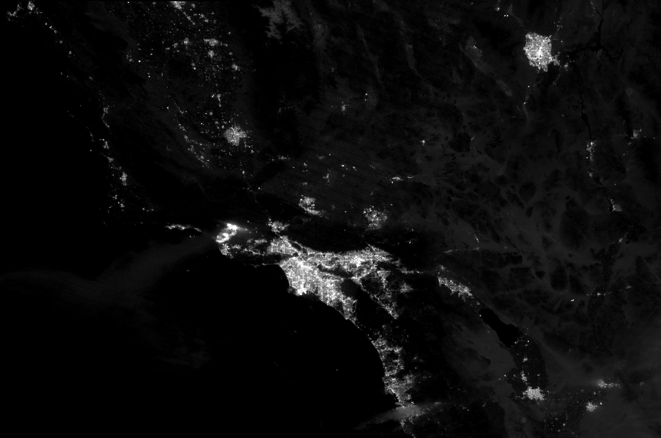
The Suomi NPP satellite captured this nighttime image of the fire Ventura fire. After burning for roughly one day, the blaze had charred 50,000 acres (20,000 hectares), destroyed at least 150 structures, and forced more than 27,000 people to evacuate. The fire was imaged by a “day-night band” in the satellite’s optics that detects light in a range of wavelengths from green to near-infrared and uses light intensification to detect dim signals.
Wednesday, Dec. 6
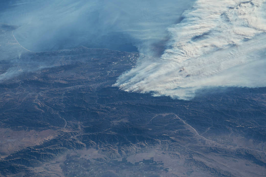
Expedition 53 Commander Randy Bresnik aboard the International Space Station took this photo of the California wildfires in the Los Angeles area on Dec. 6, 2017.
Thursday, Dec. 7

Smoke from massive fires burning across southern California seen from the International Space Station. The Thomas fire carved a path of destruction from the Pacific Ocean to 10 miles inland south along the coast, forcing mandatory evacuations for tens of thousands of residents.
Thursday, Dec. 7
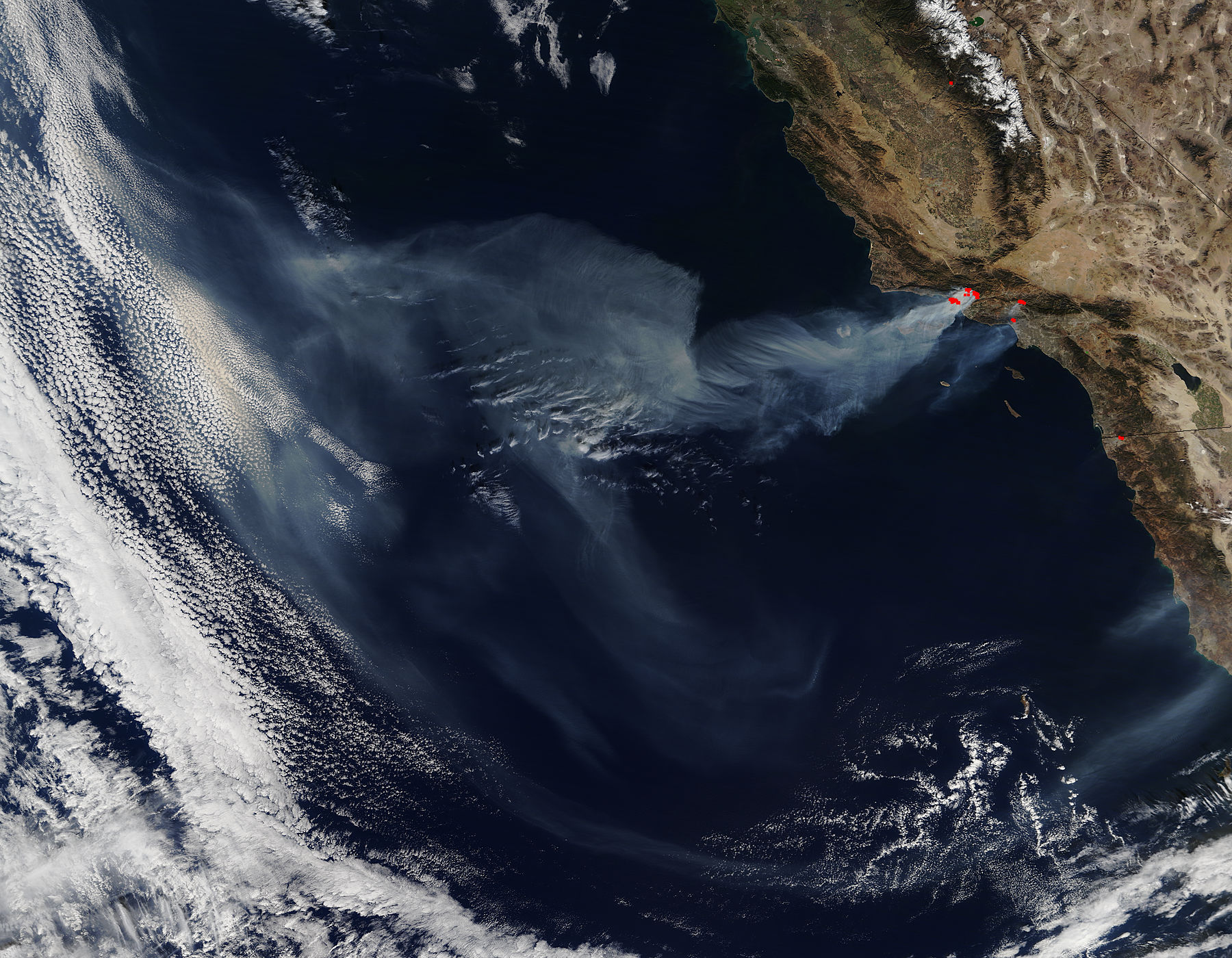
NASA’s Terra satellite collected this natural-color image of the California wildfires. Actively burning areas are outlined in red. Each hot spot is an area where the satellite’s thermal detectors recognized temperatures higher than background. When the picture was taken, none of the fires was even 15 percent contained.
More Must-Reads From TIME
- The 100 Most Influential People of 2024
- Coco Gauff Is Playing for Herself Now
- Scenes From Pro-Palestinian Encampments Across U.S. Universities
- 6 Compliments That Land Every Time
- If You're Dating Right Now , You're Brave: Column
- The AI That Could Heal a Divided Internet
- Fallout Is a Brilliant Model for the Future of Video Game Adaptations
- Want Weekly Recs on What to Watch, Read, and More? Sign Up for Worth Your Time
Write to Jeffrey Kluger at jeffrey.kluger@time.com