
Today, the border between the United States and Mexico is clearly delineated. But it was far hazier in 1821, when Mexico gained its independence from Spain. Then, the boundary was vast and never formally surveyed, stretching from modern day Oregon to Louisiana. California, Texas and most of the current U.S. southwest were part of Mexico.
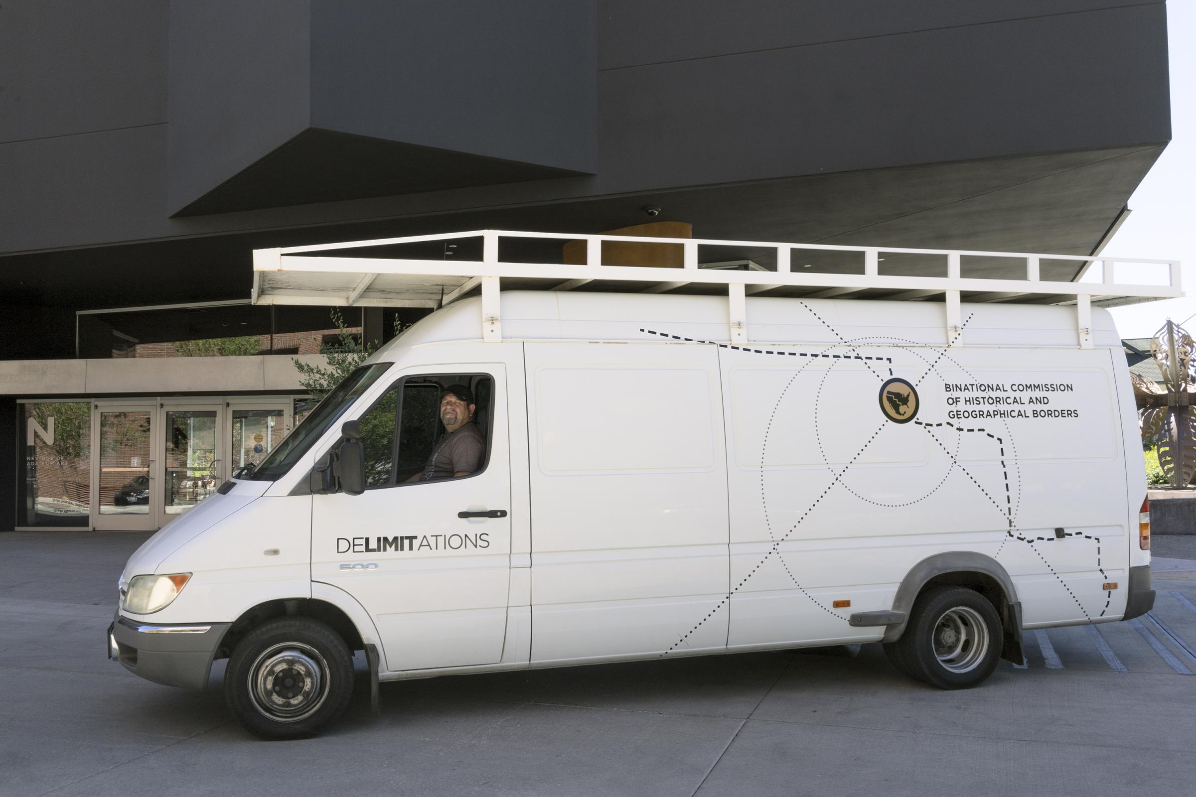
In July, David Taylor, a multimedia artist and professor at the University of Arizona, and Mexican visual artist Marcos Ramirez, known as ERRE, set out to mark this border for the first time in a multi-disciplinary project titled Delimitations. “[This is] about the transitory nature and ephemerality of borders,” says Taylor. “We live with borders all the time and we depend on their permanence. But, in fact, history does not support them as static phenomena, they move around all the time.”
Taylor and Ramirez traveled in a van along the 1821 border, from Brookings, Ore. to Port Arthur, Tex., marking coordinates with 47 obelisk-shaped monuments forged out of galvanized steel – similar to the 276 obelisks that mark the contemporary US-Mexico border, which Taylor previously documented in Working the Line.
“One thing that we found really fascinating,” Taylor says, “was going to places like Medicine Bow, Wyoming, which would have been a border town. People had no concept of the fact that Mexico stretched that far north. They don’t realize that literally 2,400 miles of border moved far enough south that what is now parts of Wyoming and Oklahoma and Colorado and all of California, Utah, Nevada, Texas, New Mexico, and Arizona was all Mexico.”
The project examines historical borders and calls attention to their shifting nature, not just in concept but also in practice. The steel monuments aren’t meant to be permanent. They can shift location through human or natural intervention, mirroring the characteristics of borderlines throughout the world. Taylor and Ramirez recorded the GPS coordinates of the monuments so that the entire “border” they created can be viewed on Google Earth. Now, the map shows an almost perfect version of the 1821 U.S.-Mexico border. But over time it will erode.
The geographic erosion echoes a cultural fusion. There are many ethnic Mexicans, living in areas that used to be Mexican territory and are now part of the U.S., and who have lived on the same land for generations. However, these U.S. citizens can, at times, face discrimination because of their heritage.
“We’re thinking about the tangibility and permeability of borders while we were doing the project,” Taylor says. “And there’s real life drama and tragedy unfolding on the contemporary border. The idea that there is another history that needs to be acknowledged so we can grapple with the situations that we are considering today, that has a real tangible value.”
Taylor stresses that one of the most important aspects of this project was that he and Ramirez collaborated together as a “bi-national committee,” contributing insight and influence from both sides of the border. Taylor recalls his counterpart saying profoundly: “the Mexican-American war was a wound, but since the border was never surveyed, there’s no scar.”
“We [wanted to do] something that would prompt people to really think about what we were doing,” Taylor says. “And the people that we met really rose to the occasion. Possibly we need to look other places for having a thoughtful conversation about these [immigration] issues. Maybe the folks who have the bully pulpit aren’t the best people to be doing the speaking.”
David Taylor is a multimedia artist and professor at the University of Arizona in Tucson.
Marisa Schwartz is an Associate Photo Editor at TIME.com. Follow her on Twitter and Instagram.


More Must-Reads From TIME
- The 100 Most Influential People of 2024
- The Revolution of Yulia Navalnaya
- 6 Compliments That Land Every Time
- What's the Deal With the Bitcoin Halving?
- If You're Dating Right Now , You're Brave: Column
- The AI That Could Heal a Divided Internet
- Fallout Is a Brilliant Model for the Future of Video Game Adaptations
- Want Weekly Recs on What to Watch, Read, and More? Sign Up for Worth Your Time
Contact us at letters@time.com