Since it launched in 2007, Google Street View has become the closest thing we have to a teleportation device. With a few keystrokes, you can go somewhere without actually going there, walking sidewalks in Paris one moment and poking into Mumbai shop windows the next.
But Google’s virtual map of the world has always been limited to the present — or at least the most recent images transmitted by its camera-equipped vehicles. Each time those vehicles captured a site, the new images would become searchable and the old ones were taken down and relegated to Google’s servers.
Now, Street View is trying to turn its teleportation device into a time machine. Starting today, all the Street View images taken over the last seven years will be viewable as part of a new feature that allows users to see how places have changed since Google began photographing the globe’s nooks and crannies. It happens in a whirl. Buildings that took years to construct magically appear in moments. Neighborhoods humming with life one year are wiped away by natural disasters the next. Billboards featuring flip phones suddenly show smartphones.
“Our original goal with Street View was to build a map that is useful, accurate and comprehensive,” says Vinay Shet, a Google product manager. “So we’ve been capturing all these snapshots, and we thought, let’s use all this data and create something that users will love, that will be exploratory, and hopefully will be useful.”
The time lapse feature will appear in a window within Street View, along with a bar users can manually toggle to change years. (It includes a substitute for Pegman, the little yellow guy users drag to launch Street View. On time lapse, your guide is an avatar that looks an awful lot like Dr. Brown from Back to the Future.)
There will also be double the number of Street View images that were previously accessible. Google Trekkers have driven more than 5 million miles in 50 countries since 2007 and have gone many places more than once, giving most locations at least one time-lapsed layer.
Google’s most engaging images often involve construction and destruction. One World Trade Center in New York City and Rio de Janeiro’s World Cup stadium rise in seconds, while areas affected by the Japanese tsunami become instantly obliterated.
“It’s only been seven years,” Shet says, “but it’s amazing how many interesting changes we’ve found.”
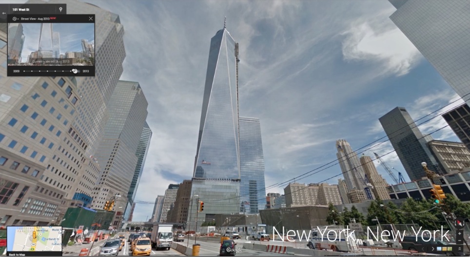
One World Trade Center, New York City
April 2009 – August 2013
The construction of One World Trade Center began in 2006, but for the first few years most of the work was below-ground. Much of the above-ground construction took place right as Google began capturing it from Manhattan’s West Street.
Soumaya Museum, Mexico City
October 2010 – November 2011
This Mexico City art museum was financed by Carlos Slim, the world’s richest man. The modern, showpiece structure was constructued in a little over a year.
The Howard Theatre, Washington, DC
July 2009 – May 2012
The historic Howard Theatre, built in 1910, was in danger of closing a century later but underwent a massive $29 million renovation that began September 2010. It reopened in April 2012.
Marina Bay Sands Resort, Singapore
November 2008 – May 2013
The hotel, considered the most expensive building in the world at $5.7 billion, includes three 55-story towers with more than 2,500 rooms. It opened in June 2010.
Graffiti on Bowery Street, New York City
June 2009 – August 2013
The side of a building on Bowery Street in New York’s Lower East Side neighborhood that’s seen a steady rotation of street artists.
Naucalpan, Mexico
November 2008 – October 2013
An overpass gets built over an existing street in Naucalpan, Mexico, just outside of Mexico City.
Brazil World Cup stadium, Fortaleza, Brazil
February 2012 – September 2013
A soccer stadium slowly rises in Fortaleza, Brazil, one of the host cities for the 2014 FIFA World Cup.
More Must-Reads From TIME
- The 100 Most Influential People of 2024
- The Revolution of Yulia Navalnaya
- 6 Compliments That Land Every Time
- What's the Deal With the Bitcoin Halving?
- If You're Dating Right Now , You're Brave: Column
- The AI That Could Heal a Divided Internet
- Fallout Is a Brilliant Model for the Future of Video Game Adaptations
- Want Weekly Recs on What to Watch, Read, and More? Sign Up for Worth Your Time
Contact us at letters@time.com